Happy GIS Day! Today we celebrate geographic information systems (GIS) technology and help unite the geospatial community in a global movement of collaboration, sharing and education.
 GIS technology makes a positive difference and benefits the lives of millions of people. It enables us to make smarter decisions about land use, energy, water, natural hazards, biodiversity, climate and other key issues with geospatial analysis and insights.
Here’s a look at a Holland Engineering, Inc. project that involved GIS and a Phase II Site Assessment in Detroit, Michigan:
The primary objective of the Phase II ESA was to evaluate further the potential presence of Recognized Environmental Conditions associated with past uses of a brownfield redevelopment and adjacent properties.
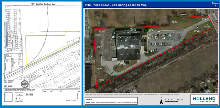
Historic resources provided a plethora of information to the Holland Engineering, Inc. team about the Subject Sites’ background. Previous investigations documented the presence of railroad siding between 1926 and 1967. Historical maps and aerial photographs dating back to the early 1900’s indicated disturbed soils and material, equipment, and vehicle storage in the past.
 Due to the historical map being a scanned, it did not contain spatial reference information. Therefore, the map did not align properly with the rest of the data collected by HEI. For us to be able to use the historical map in conjunction with the rest of our spatial data, we needed to align or georeference the historical map into a coordinate system. Using the Georeferencing Tool in ArcMap, HEI was able to align parcel boundaries of the historical map and the present-day aerial basemap. Features on the scanned map, such as the railroad, were then digitized to become a layer on the map. By utilizing GIS, the Environmental Team was able to conclude that the soil borings containing high toxin concentrations were located where railroad siding was previously present on the site.
If you’d like to learn more about our GIS and Phase II ESA project, follow this link.
Happy mapping!